DAR ES SALAAM
A short introduction to Dar es Salaam
Dar es Salaam covers approximately 1,590 km² and is the most populous and biggest commercial city in Tanzania. Dar es Salaam dates back to the 1800s during the Arab occupation and is situated on the coast of the Indian Ocean (6°48' South, 39°17' East). The city originated from a fishing village called “Mzizima” which later turned into the Sultanate Majid Said of Zanzibar city, thus getting its current name from Arabic translating to abode/home (Dar) of peace (es Salaam).
Dar es Salaam is a rich historical city that has experienced Arabic occupation, Germany occupation and a British protectorate, gaining independence in the 1960s. Due to Western colonialisation, the city was socially, economically, and physically subdivided into three zones where zoning enhanced social segregation. The first zone was the European, followed by the Asians and African settlements. The town's growth was facilitated by its role as the administrative and commercial centre of German East Africa and industrial expansion resulting from the construction of the Central Railway Line in the early 1900s.
From the end of the Second World War, Dar es Salaam was under the British protectorate up until the Independence of Tanzania in 1961. After independence, population grew at an unprecedented rate. The city's population also included a large number of workers from British India, many of whom came to take advantage of the trade and commercial opportunities Tanzania presented. Rural-urban migration has been a trend since the colonial era where people migrate from predominantly agrarian rural areas to urban centres. Dar es Salaam continued to serve as the capital of Tanzania, even when in 1964 Tanganyika and People's Republic of Zanzibar merged to form Tanzania. In 1973, however, provisions were made to relocate the capital to Dodoma, a more centrally located city in the centre of Tanzania. The relocation process has not yet been completed, and Dar es Salaam remains Tanzania's primary city.
Geo-politically, the city is divided into five Municipal Councils namely Kinondoni, Ilala, Temeke, Kigamboni and Ubungo. The city is estimated to have a population of about 5.6 million people which is about 10% of the Tanzanian population. Dar es Salaam is among the three fastest-growing cities in Africa and among the tenth most urbanized in the world with her 75%-85% inhabitants living in informal settlements.
Dar es Salaam has seen urban agriculture since the 1970s when the “Agriculture for all” policy was established in Tanzania. During that time, civil servants were allowed to conduct farming activities in open spaces and all land which was not developed as a means to fight hunger and alleviate poverty. From the 1980s, researchers started examining the scale and impacts of urban farming activities. Currently, urban and peri-urban agriculture (UPA), in the form of vegetable cultivation and livestock keeping, is a significant source of food and income to some urban dwellers in Dar es Salaam. Livestock keeping relies on affordable land being available where; different ethnic groups keep dairy cattle. Thus, extensive livestock rearing, dairying, and egg production occur in these peri-urban areas.
Poultry keeping is growing because demand for eggs in the urban market promises quick returns. Poultry are kept indoors in sheds of about 35 square metres that may accommodate up to 300 chickens. In recent years, food production in peri-urban areas is increasingly carried out by high-income groups who commute to farms on the city periphery or who have moved and reside there permanently (UNEP, 2014). Poultry keeping and dairy cattle has significant improvement for food security (UNEP, 2014; Lupala & Kreibich, 2008). Currently, UPA is practiced in all five municipalities where the practice and successes of UPA depend on the size of the land and scope of UPA practices.


.jpg)
.jpg)
.jpg)
.jpg)
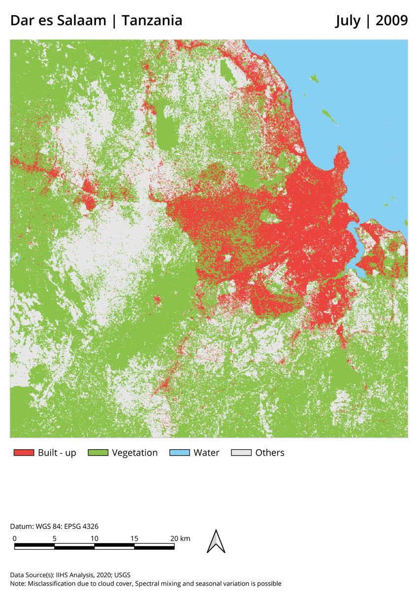
Figure 1: Dar es Salaam population trend from 1950 to 2020 (Data Source: UN World Population Prospects)
Photo 1: Dar es Salaam Downtown area
Photo 2: Peri-urban agriculture in open space, Msimbazi Valley (Source: Author)
Photo 3: Vegetable farming in open space, Msimbazi Vallery (Source: Author)
Photo 4: Farmers' preparing their fields, Msimbazi Vallery (Source: Author)
Photo 6: Poultry keepers and farmers with Royal Academy team and Enumerators, Oysterbay
(Source: Author)
Figure 2: A visual comparison of Dar es Salaam's expanding built-up areas, between the years 2009 and 2019. (Source: Teja Malladi, et al. Geospatial Lab, Indian Institute for Human Settlements).